Guidelines for submitting articles to Santa Rosalia Today
Hello, and thank you for choosing Santa Rosalia.Today to publicise your organisation’s info or event.
Santa Rosalia Today is a website set up by Murcia Today specifically for residents of the urbanisation in Southwest Murcia, providing news and information on what’s happening in the local area, which is the largest English-speaking expat area in the Region of Murcia.
When submitting text to be included on Santa Rosalia Today, please abide by the following guidelines so we can upload your article as swiftly as possible:
Send an email to editor@spaintodayonline.com or contact@murciatoday.com
Attach the information in a Word Document or Google Doc
Include all relevant points, including:
Who is the organisation running the event?
Where is it happening?
When?
How much does it cost?
Is it necessary to book beforehand, or can people just show up on the day?
…but try not to exceed 300 words
Also attach a photo to illustrate your article, no more than 100kb
PROPERTY SEARCH
article_detail
Date Published: 13/10/2026
Where does your town actually end? Murcia launches a fix for 19th century border confusion
New working group will help councils pin down boundaries that haven’t been properly checked in over a century
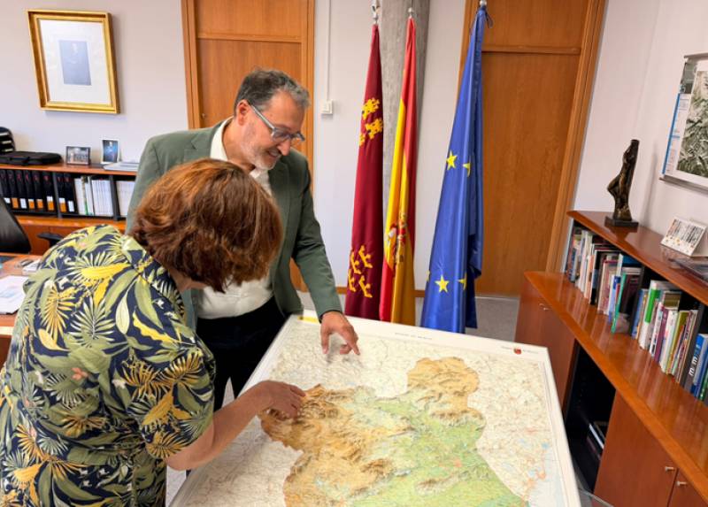
Ever wondered exactly where your municipality ends and the next one starts? It’s a trickier question than you might think, and the Region of Murcia has just set up a dedicated team to sort it out once and for all.
The regional government has created a Working Group on Territorial Delimitations, a mouthful of a name for a genuinely useful idea: helping local councils work out, with proper modern precision, where one municipality’s boundary stops and another’s begins. It’s not just an academic exercise either. Boundaries affect everything from urban planning and land registry to who’s actually responsible for fixing a pothole or maintaining a public space near a border.
The root of the problem goes back further than you’d expect. Much of the boundary data still in use today comes from field notebooks and records compiled at the end of the 19th century, during work on the National Topographic Map. Surveyors back then relied on physical landmarks, roads, ravines, houses, and other visible features, to mark where one territory ended and another began. The trouble is, more than a century on, a lot of those landmarks have changed, moved, or simply vanished, leaving some boundary lines on paper not quite matching reality on the ground.
The new group was formally created by a joint order published last Thursday 8 October in the Official Gazette of the Region of Murcia, and will be coordinated by the Ministries of the Presidency, Youth, Foreign Action and Emergencies, and Infrastructure and Territorial Development. It’s worth stressing this isn’t about redrawing the map of the Region’s 45 municipalities wholesale. The aim is far more modest: using today’s mapping technology to spot and correct cartographic inaccuracies where they exist, not to shift anyone’s actual territory.
Javier Rollán, Director General of Territorial Planning and Architecture, explained the thinking behind it. “The objective is for municipalities to have specialized support when there is any inaccuracy in the geometry of the line that separates two municipalities and to be able to have the necessary cartographic and technical information to analyze it,” he said.
Francisco Abril, Director General of Local Administration, pointed to the practical benefits for residents and councils alike. “A precise delimitation allows us to know with greater certainty which administration is competent over a given territory and facilitates the management of services and actions that directly affect citizens,” he said.
Councils themselves won’t be left out of the process either. Any municipality whose boundary comes under review can take part in the discussions, sending along technical or legal staff, with outside experts brought in where a case needs specialist knowledge.
It’s worth being clear about what this group can’t do too. It has no power to unilaterally change a municipal boundary, and it won’t replace the official bodies legally responsible for resolving genuine boundary disputes. Its role is purely technical and advisory, helping gather the right information and coordinate between the administrations involved. Often, that might simply mean transferring an already agreed boundary onto a modern, accurate map rather than untangling any real conflict.
Under the published rules, members of the group must be appointed within one month of the order taking effect, with the first official meeting due to follow within two months after that. For now, it’s a quiet but potentially quite significant piece of housekeeping for the Region, the kind of thing that rarely makes headlines but could save plenty of confusion down the line.




















 Ever wondered exactly where your municipality ends and the next one starts? It’s a trickier question than you might think, and the Region of Murcia has just set up a dedicated team to sort it out once and for all.